 Jacob
Auspitz
Jacob
Auspitz
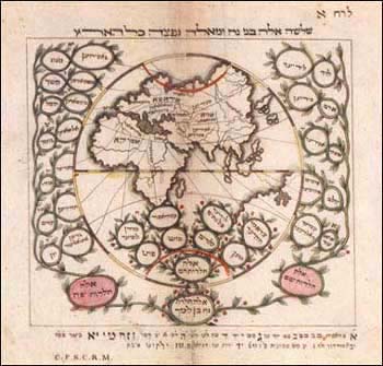
World Map from First Jewish Atlas
Shlosha Eleh Bnai Noah u-M’eleh Naftzah Kol ha-Aretz
(These Are the Three Sons of Noah and from These the Land was Overspread)
from Be’er ha-Luhot
Printed by A. Geunther
Budapest (Ofen), 1817
The title of this map is taken directly from Genesis 9:19, the source of the common belief that following the Great Flood, the world was repopulated and all the nations founded by Noah’s sons, Shem, Ham, and Japheth, and their descendants. This chart shows the three branches of Noah’s family tree beginning at the lower border with vines extending for Shem on the right, Japheth on the left, and Ham in the center. Each vine forms many miniature labels, which include both the biblical designation of a particular nation as well as its more commonly used vernacular name. From each tendril, a delicate wisp connects it to the assumed location of that people on one of the three continents shown.
The references used
by Auspitz to identify these connections reflect a wide familiarity with
classic as well as contemporary sources. His footnotes, shown at the bottom
of the map, cite the Bible, Rashi (eleventh-century commentator), Zemah
David (sixteenth-century historical work by David Gans), Talmud, Midrash,
and the Biur of Moses Mendelssohn (eighteenth-century philosopher of the
German Enlightenment). Only once, in the case of Assyria and its correspondence
to the biblical Ashur, does Auspitz rely on the pretext of general knowledge
in lieu of research into the source material. That this documentation
appears at all is an indication of the new “scientific” direction
mapmaking was taking, even in documenting such an unscientific scenario.
![]() enlarge
enlarge
![]()