 Daniel
Stoopendaal
Daniel
Stoopendaal
Beschryvinge van Jerusalem
(Plan of Jerusalem)
Printed by Pieter Keur and Pieter Rotterdam
Dordrecht, ca. 1700
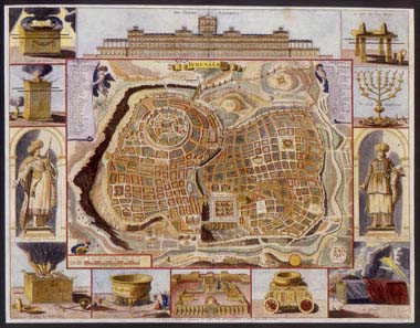
This completely imaginary plan of Jerusalem is based on the work of Juan Bautista Villalpando (1552 – 1608), whose map of the Holy City appeared in the commentary to Ezekiel co-written by Villalpando and Hieronymus Prado in 1604. Among the sources that influenced this vision of the city were the writings of Josephus. The principal features of the city are the Temple Mount in the center of the map and “City of David,” a walled enclosure, seen here in the southwestern corner (upper left) of the city.
The nine square courtyards
within the Temple court are based on Villalpando’s interpretation
of Ezekiel’s prophecy of a Third Holy Temple. Surrounding the city
walls are the encampments of the armies that besieged Jerusalem throughout
the course of history. The entire map is surrounded by twelve vignettes
relating to the Temple of Solomon.
![]() enlarge
enlarge![]()